Chlef
Chlef
- Code:
- 02
- Name in arabic:
- الشلف
- Name in english:
- Chlef
- Name in berber:
- ⴰⴳⴻⵣⴷⵓ ⵏ ⵛⵍⴻⴼ
- Phone Code:
- 27
- Zip code:
- 02000
- Population:
- 1 002 088 hab. (2008)
- Area :
- 4 791 km2
Presentation of the wilaya
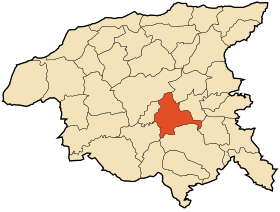
The wilaya of Chlef (in Arabic : ولاية الشلف , in Berber : ⴰⴳⴻⵣⴷⵓ ⵏ ⵛⵍⴻⴼ ), is an Algerian wilaya located in the north-west of the country halfway between Algiers and Oran .
The wilaya covers an area of 4074 km2.
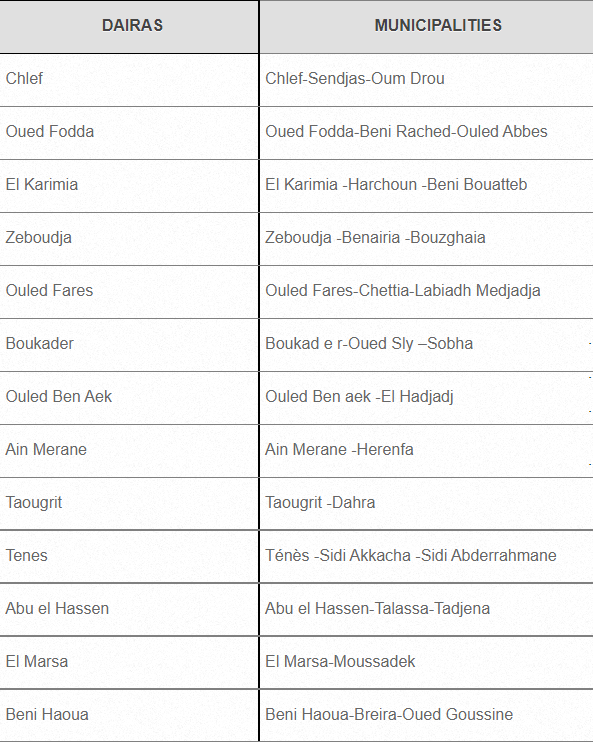
ADMINISTRATIVE ORGANISATION
Numbers of Daïras: 13.
Numbers of municipalities: 35.
|
|
|
|
GEOGRAPHICAL SITUATION (Relief - Climate, etc.)
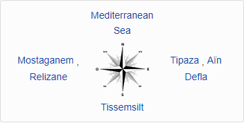
The wilaya of Chlef is located in the western Tell 200 km (up to 300 km for the northwestern municipalities) west of Algiers . It is bounded by
■ The Mediterranean in the North.
■ The wilaya of Tissemsilt in the South.
■ The Wilaya of Mostaganem and Relizane in the West.
■ The Wilaya of Ain DEFLA and Tipaza in the East.
Relief
The wilaya is formed by four geographical groups :
· a Mediterranean coast extending over 120 km ;
· the Dahra chain to the north ;
· the mountains of Ouarsenis to the south ;
· the Chelif valley between the two mountainous areas
Weather
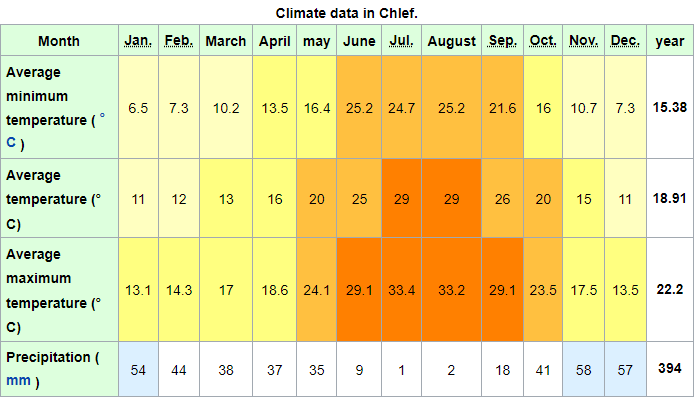
The wilaya is characterized by a sub-humid Mediterranean climate in the northern part and a continental climate in the south, cold in winter and hot in summer 3 . Located in a basin separated from the sea by the Dahra mountains . Despite its sub-humid climate, Chlef is one of the hottest regions in Algeria . The average rainfall is 420 mm / year
NATURAL POTENTIALITIES
Forests
It is distinguished by an important forest massif, made up in particular of cork oaks and holm oaks with a diverse fauna.
ECONOMIC POTENTIALITIES
Agricultural potentials
the wilaya of Chlef is essentially based on agriculture and breeding.
The wilaya of Chlef is characterized by an agricultural vocation, it is located on the plain of the Middle Chelif and has significant water resources. The agricultural area represents 65.43 % of the total area of the wilaya.
Agricultural production is made up of diversified crops : cereals , pulses, arboriculture, fodder, industrial crops, etc. The fauna in the wilaya is also diverse : cattle, sheep and goats
Industry
Main industries:
❖ Public Sector
- ECDE: Cement 42.6 A / CPJ CEMII
- NOVER SPA: Glass
- ECO: Sanitary ceramics
- COSIDER: Cement Channels
- FIPEXPLAST: Plastic and rubber processing
- LAMIPLAST: Decorative plates
- SOTUPLAST: Plastic pipes
- SONARIC: Assembly of household appliances
- National Transcana Company: Cement Canals
❖ Private sector
- Sanitary Ceramics
- Red products
- Sand for Construction
- Prefabricated
- Wire mesh, wire rope
- Butane gas cylinder filling
- Production of Pharmaceutical and Parapharmaceutical materials
- Agri - food
- General Carpentry and School Furniture
- Printing and office equipment
Industrial Zone

Activity zones
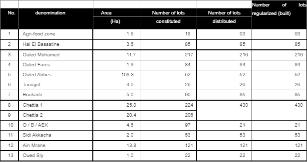
ECONOMIC, ADMINISTRATIVE AND SOCIAL INFRASTRUCTURES
Hydraulic
The wilaya is crossed by dozens of wadis :
· Chellif ;
· Oued Fodda ;
· Oued Sly.
-On the other hand, this wilaya has hundreds of natural water sources .
-It includes the following dams :
· Sidi Yakoub dam ;
· Oued fodda dam.
Road network

|
|
Rail network:
■ The wilaya is crossed by a railway line from the east from the limits of the wilaya of Ain Defla, to the west at the limit of the wilaya of Relizane, extends over a distance of 67 , 8 km including four main stations: Oued Fodda, Chlef, Boukader and Oued
Sly.
Network port
■ Ports: The coast of the province extends over a distance of 120 km from the boundary of the wilaya of Tipaza - Is the limit of the wilaya of Mostaganem - West, it has three port infrastructure:
Monograph the Wilaya of CHLEF
■ Port of TENES: Specializing mainly in trade (building materials and cereals) as well as sea fishing, this port occupies an area of 07 ha and a wharf of 135 linear meters.
■ EL MARSA fishing port: Specializing mainly in sea fishing, occupies an area of 05 ha and a quay of 508 linear meters.
■ BENI HAOUA fishing shelter: Occupies a sea surface of 03 ha and a wharf of 135 linear meters.
Airport network
■ An international airport located in the capital of the wilaya.
Education :
The wilaya has primary schools, CEMs and high schools as well as CFPA, INSFP and CFPA annexes.
Health :
The wilaya has hospitals, polyclinics and treatment rooms.
· Ouled Mohamed Hospital.
· Chorfa Hospital.
· Zighoud Youcef Ténès Hospital.
· Ténès old hospital.
· Sobha Hospital.
· Chettia Hospital.
· Hospital of the Bedj sisters .
TOURIST ACTIVITIES
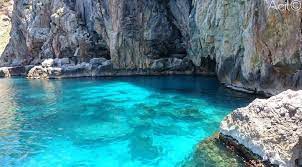
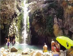
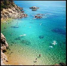
It should be noted that the Wilaya of Chlef is a tourist region. In addition to its coastal strip which stretches over more than 120 km, i.e. 10% of the entire Algerian coast, its tourist wealth is more justified given the existence of a diversified relief and the presence of forests of Aleppo pine and heather, which extend over thousands of hectares.
Coastal region which includes the sites of TIGHEZA, BENI HAOUA, TERARNIA, OUED El MALAH, and the sites of MAINIS, and the MASSIF of OUARSENIS.
11, rue de la resistance, Chlef, Algeria
 Contact details of the Chamber of Commerce and Industry of
Chlef
CCIC / Chamber of Commerce and Industry of Chelif
- Address:
- 11, rue de la resistance, Chlef, Algeria
- Email:
-
cci-chelif@caci.dz
- Mobile:
- There is no primary mobile phone
- Landline number:
-
027 77 54 22
027 79 04 06
- Fax:
-
027 77 54 22
027 79 04 06
- Viber:
- There is no viber account
- Work hours:
- We don't have this information.
