Algiers
Algiers
- Code:
- 16
- Name in arabic:
- الجزائر
- Name in english:
- Algiers
- Name in berber:
- ⵜⴰⵎⵏⴰⴹⵜ ⵏ ⵍⴻⴷⵣⴰⵢⴻⵔ
- Phone Code:
- 023
- Zip code:
- 16000
- Population:
- 3 154 792 habitants. (2015)
- Area :
- 1 190 km2
Presentation of the Wilaya
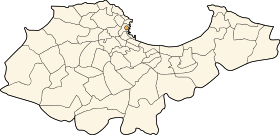
Due to its status, its size and its functions, Algiers is considered as the first city of Algeria. Algiers is also the capital of the country. Therefore, it is the most populous city. It includes the highest population density at national level, as well as service activities , equipments, infrastructures, research centers, industries and major urban projects. Algiers is the political, administrative and economic capital of the country. It is the seat of all central administrations, political and social institutions, major economic and financial establishments, major decision-making centers and diplomatic representations. Algiers has a good network in communication and telecommunication networks.
The wilaya of Algiers (in Arabic : ولاية الجزائر / in Berber : Tamnadt n Ledzayer / in tifinagh : ⵜⴰⵎⵏⴰⴹⵜ ⵏ ⵍⴻⴷⵣⴰⵢⴻⵔ ) is an Algerian administrative subdivision located in Algiers. Its capital (prefecture) is Algiers.
While Algiers is the most populated wilaya in Algeria with 3 154 792 inhabitants, it is also the smallest, with an area of 1,190 km2 .
Wilaya of Algiers consists of thirteen daïras (administrative districts), each comprising several municipalities, for a total of fifty-seven municipalities . It also has several directions.
GEOGRAPHICAL SITUATION (Relief - Climate, etc.)
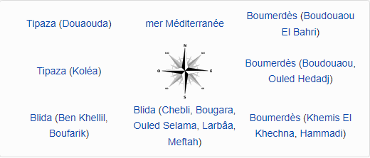
The Wilaya is located on the north-central coast of the country and has a seafront of 80 km. It is limited by : -
The Mediterranean Sea to the North;
- The Wilaya of Blida in the South;
- The Wilaya of Tipaza in the West;
- The Wilaya of Boumerdes in the East
Located in the Tell , in the North of Algeria , the wilaya has a Mediterranean climate where the summers are hot and dry and the winters are mild and rainy and sometimes snowy.
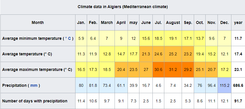
Old series of observations first started in 1843, then in 1884 .
The wilaya of Algiers receives annual amounts of precipitation varying on average between 400 mm and 1,200 mm. It is therefore wetter than the rest of the country .
The hail may befall accompaniment of heavy rain, and possible snowfall on the hills. This hail melts quite quickly.
The snow falls rather on the high zones of Bouchaoui, Bouzaréah , Chéraga , Ben Aknoun , Bir Mourad Raïs and Douéra . Its thickness then reaches in some places, nearly 10 cm . The main roads are frequently blocked . Municipalities must be equipped to deal with it, under penalty of major traffic jams during peak traffic hours on several major roads 13 .
In the coastal wilaya of Algiers, winter temperatures vary between 8 ° C and 15 ° C. They climb to 25 ° C in May to reach an average of 28 ° C to 30 ° C in July and August. During snowfall, the temperature can drop to less than 6 ° C .
The wilaya of Algiers has annual average wind speeds estimated at an altitude of 10 meters between 1 m / s and 6 m / s. This coastal wilayas in Algeria lies between 2 e class wind in Metidja and 3 th class in Kabylia .
ECONOMIC POTENTIALITIES
Agricultural potentials
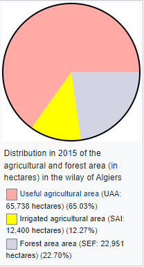
The total agricultural land used in the wilaya of Algiers is 37,209 hectares for a total area of the wilaya of 80,922 hectares .
The main crops are durum , the wheat , the barley , the industrial tomato , the gardening , the citrus fruits , the fruit and olive trees .
The total area of cereals is 1,129.75 hectares , while the total area of arboriculture is 11,541 hectares .
Indeed, the total area of the Wilaya of Algiers is divided between cereal crops, arboriculture, viticulture, irrigated crops, rangelands, bare soils, forest areas, the built environment, etc.
These agricultural potentials are undeniable and result in significant agricultural activity generating a very diversified and quality production in terms of table vines, fruit trees, citrus fruits, market gardening, oils, and red and white meats. .
Agricultural land in the wilaya of Algiers is classified in zone " One ".
This " One " zone is characterized by a very good quality of agricultural land and its richness in products favoring agricultural activities, as well as by a favorable climate, in particular a fairly high rainfall, reliefs facilitating the work of the land and easy access. mechanical means to farms (plains) in addition to the abundance of water.
Industry
Algiers is the most attractive economic and administrative center of the territory. It concentrates 4 industrial zones and 26 activity zones and a quarter of the foreign investments declared in the country. It constitutes a hub of national activity and a crossroads of exchanges.
- The wilaya has 4 industrial zones and 26 activity zones.
- Houari Boumediene airport: with two runways, one main and the other secondary.
- Port Infrastructures: Algiers has 4 ports: Algiers, Rais Hamidou, El Djamila and El Marsa.
Hydraulic
- The wilaya is crossed by several wadis
- The province enjoys the water dam Douéra (87 000 000m 3 ), as well as water dams of wilayas bordering.
- The wilaya has more than 200 water reservoirs.
- The wilaya has more than 65 pumping stations .
- The wilaya includes more than 244 boreholes and wells
- The wilaya has several treatment plants that are part of the general Algiers sanitation scheme, which has as its main objective the collection of wastewater generated by the population of all of its 57 municipalities.
- Béni Messous wastewater treatment plant : 250,000 equivalents / inhabitants .
- Réghaïa wastewater treatment plant : 400,000 equivalents / inhabitants .
- Baraki wastewater treatment plant : 900,000 equivalents / inhabitants .
- Zéralda wastewater treatment plant : 100,000 equivalents / inhabitants .
- Mahelma wastewater treatment plant : 4,000 equivalents / inhabitants .
These treatment plants prevent domestic and industrial wastewater from being discharged into the sea or into wadis. Thanks to them, the beaches of the Algerian coast will be authorized for swimming, without bathers having to worry about their pollution.
From 2018, no drop of wastewater will be discharged into the sea or into the wadis anymore, because 100 % of the wastewater generated by the capital will be purified.
- The province has the desalination plant of Hamma , with a capacity of 200 000 m 3 per day. The station is intended to provide drinking water to the inhabitants of the city of Algiers and its region. Operational since February 24, 2008 , it uses the technique of reverse osmosis.
Road network
- A road network made up of 113 km of express network, 307 km of national roads, 308 km of wilayas roads and 816 km of municipal roads.
The wilaya of Algiers is served by several national roads :
- National road 1 : RN1 ( Route de Tamanrasset ).
- National road 5 : RN5 ( Route de Constantine ).
- National road 8 : RN8 ( Route de Bou Saâda ).
- National road 11 : RN11 ( Route d'Oran ).
- National road 24 : RN24 ( Route de Béjaïa ).
- National road 36 : RN36 ( Route de Dély Ibrahim ).
- National road 38 : RN38 ( Route de Bourouba ).
- National road 41 : RN41 ( Route de Sidi Fredj ).
- National road 61 : RN61 ( Route de Boufarik ).
- National road 63 : RN63 ( Route de Zéralda ).
- National road 67 : RN67 ( Route de Hadjout ).
- East-West highway .
- Maritime network:
- Port of Algiers: 1st commercial port in the country, sheltering:
■ 37 docks,
■ Container terminal with a capacity of 1 million boxes. El Djamila fishing port: with a capacity of 132 units.
Port of Rais Hamidou: with a capacity of 07units (small fishing boats). Port of El Marsa: with a capacity of 34 units (small trades). - Rail network:
- The rail in the province of Alger presents a variety of means such as gear , the tram and metro .
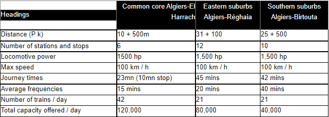
Airport infrastructure:
Houari BOUMEDIENE International Airport
Education :
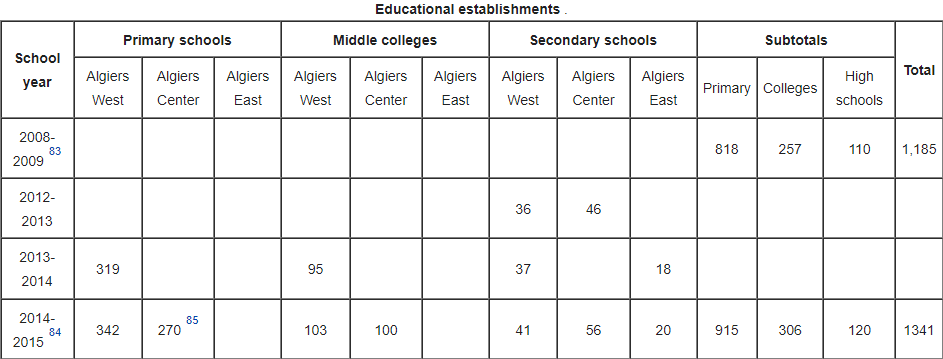
The wilaya of Algiers is home to several universities , institutes and schools that are part of the Algerian university .
Professional training :
The vocational training sector also has a number of establishments reaching 15 5 units and offering 10,400 teaching places.
Health :
- The health sector has 4 university hospital centers, 13 specialized hospitals, 10 health sectors and 61 polyclinics.
TOURIST ACTIVITIES
The wilaya has 126 hotels with a capacity of 17,740 beds, 2,777 restaurants, a spa and a dozen listed monuments.
In 2004, the wilaya of Algiers had 36 beaches open for swimming. In 2012, it had opened 64 other .
In 2013, there were only five closed beaches in the municipalities of Zéralda, Hammamet, Casbah, Aïn Taya and Hussein Dey, because these beaches were still polluted.
Culture
The wilaya has several cinemas .
- Algiers Cinematheque .
- El Mouggar Cinema.
- Algeria Cinema.
- Cosmos Cinema.
- Africa Cinema.
- El Khayam Cinema.
- Zinet Cinema.
- El Thakafa Cinema.
- Frantz Fanon Cinema.
Several performance halls are located in the wilaya :
- Algerian National Theater .
- Grand Opera of Algiers.
The wilaya of Algiers has several museums :
- National Museum of Bardo .
- Algiers National Museum of Fine Arts .
- Algiers National Museum of Modern and Contemporary Art (MAMA) .
- National Museum of Antiquities and Islamic Arts .
- National Archaeological Agency.
- Algiers Museum of Popular Arts and Traditions .
- National Museum of Illumination, Miniature and Calligraphy.
- Palace of the Rais .
Consular Palace, 6 boulevard Amilcar Cabrel CP 16003 Algiers BP 100 Algiers 1er Novembre, place des Martyrs
 Contact details of the Chamber of Commerce and Industry of
Algiers
CCIM / Chamber of Commerce and Industry of Mezghenna
- Address:
- Consular Palace, 6 boulevard Amilcar Cabrel CP 16003 Algiers BP 100 Algiers 1er Novembre, place des Martyrs
- Email:
-
cci-mezghena@caci.dz
ccimezghenaalger@gmail.com
- Mobile:
-
0770 68 58 29
0770 29 28 16
- Landline number:
-
There is no main landline number
- Fax:
- There is no main fax number
- Viber:
- There is no viber account
- Work hours:
- We don't have this information.
- Website:
- http://www.cci-mezghena.dz
